
Playa Centro, Sayulita Beach
Sayulita Beach
Playa Centro or Sayulita Beach is the main beach in Sayulita and an easy two-block walk from town. At the south end of the beach are a 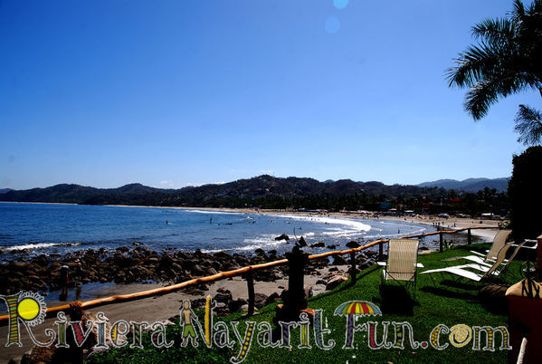 variety of restaurants, bars and cafes that line the sand. This side of the beach has
 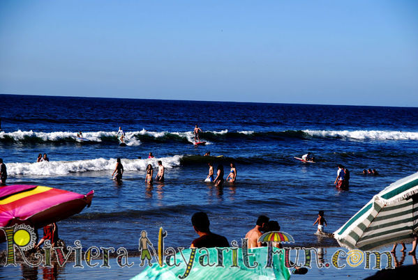 calmer water and a sandy ocean floor with a gradual slope making it better for swimming and Sayulita SUP surfing out into the calmer waters.
This is also a very popular place to learn how to surf, and SUP with easy breaking waves and plenty of surf shops to choose from. Walking north on the main beach is Playa Pilitas where the river meets the ocean. Continuing north on the beach is Playa Questos, where surfers get into the action. It has larger waves that break over a rough ocean floor with rocks and drop offs, making it the best side of the beach for boogie boarding and more advanced surfing. Sayulita beach is for the entire family!
The Many Beaches of Sayulita
The easiest Sayulita beach to get to (other than the main playa) is Playa de Los Muertos: Walk to the south (left when facing the sea) around the curve of Sayulita bay past Villa Amor on the dirt road just above the beach, and follow the dirt road left up the hill under an arch and through the cemetery. On the far side of the cemetery, turn right to the Sayulita beach Playa de Los Muertos. This Sayulita beach is very popular for families and a safe swimming beach. Huge rocks protect it on both sides making a lovely beach cove. Las Cargadas is the tiny beach past the rocks to the south of Playa Los Muertos. There are other little beaches here that are best accessed by kayak from Sayulita.
Directions from the Sayulita plaza: There is an inland route to Playa Los Muertos as well. Take Av. Revolucion passed El Espresso, (at the plaza) then your first right and follow straight for about ½ a mile. The road then turns sharp right and up a short hill where it turns left and splits. Go straight (take the right fork and follow the road for outstanding views of Sayulita and the bay; 5minutes detour) and the track will start downhill and soon enter the jungle. Two paths go off to the left for Playa Carrizitos (see below) and you continue straight on.
Playa Carricitos: At this Sayulita beach you’ll find huge waves and it’s most likely that you’ll be alone on this wild looking, windswept beach. The homes here are well hidden in the jungle above the water. There are usually waves to body-surf or boogie board at this beautiful Sayulita beach.
Directions: Starting at the Playa de Los Muertos side of the cemetery, follow the dirt road into the jungle and take the second right turn. This is a 20 minute up and downhill walk.
From the Sayulita Plaza in Town, take Ave Revolucion pass El Espresso, then first right and continue straight for about ½ a mile. The road then turns sharp right and up a short hill where it turns left and splits. Go straight and the track will start downhill and soon enters the jungle. (Take the right fork and follow the road for outstanding views of Sayulita and the bay; 5 minute detour). Take the first left turn for Playa Carrizitos. From the plaza it is a 40 minute up and downhill walk.
Playas Patzcuaro and Patzcuarito: These more remote Sayulita beach areas that take a bit more effort to get to, but provide stunning beauty and you will most likely find yourself alone here.
Directions: From the plaza in Sayulita, these beaches are an hour walk or 10-minute drive from town. Take Av. Revolucion (by the plaza and on your way out of town) and onto the road to Punta de Mita (Camino Punta de Mita), go to the right towards Huigera Blanca and Punta Mita. At the 5kms.marker take a right towards Playa Patzcuaro. However, there are no signs. About 1km. down this road you will come to a ranch. Just beyond there is a creek leading to Playa Patzcuaro.
The adventurous can also reach Playa Patzcuaro by climbing the rocks from Carrizitos.
The North Shore
It is also very important to note that there are RIP TIDES and currents on the north side of town in Sayulita. There are signs on the playa…however, many people have lost their lives being swept out to sea from a RIP TIDE. If you are ever caught in a Rip Tide, swim sideways, along the beach until you are out! Rip Tides can also have powerful undertows….so please, look for Rip Tide signs in the water, and for signs on the beach and do don’t swim in those areas! Many of the beaches along the Riviera Nayarit have a strong undertow that will take you down, and can make it very difficult to get out of the water.
You can find out more about Rip Tides by clicking here to this post.
Playas Las Cuevas & Playa Malpasos: These Sayulita beaches are to the north of Sayulita and offer privacy, jungle hikes, white sand, and beautiful clear water since there are no rivers draining into them.Two miles north (to the right when facing the sea) of Sayulita, surrounded by rocky cliffs, this tiny horseshoe-shaped bay is perfect for lovers. Carefully watch the ocean so you don’t get pushed up against the rocks and washed away when the tide comes in. Access is by a path through the jungle.
Directions: To find it, as Sayulita’s main beach ends and before the house built into the small headland, walk inland along the right-hand side of the arroyo (river valley) and get on to the jungle road. Follow this north (left) and shortly you will cross a small river (dry in the winter) the main path looks to follow the river to the right but look straight ahead and you will see several large boulders. Clamber over or go around the rocks and follow the path across a cobblestone road (which is a private road from the beach-house to the main highway) and continue straight. You will go over a small rise and a dirt road will join from the right. Approximately 50 meters further the path splits, take the smaller left fork to Las Cuevas. The path ducks under the trees going down hill and you will come upon a wall, continue to the left past a small white graffiti covered concrete block building and over a small bridge. You will see the cove open up before you. To the right of the cove there are poorly maintained steps which lead up onto the bluff which overlooks the long wild Sayulita beach of Playa Malpasos.
Playa Malpasos: If you are at Las Cuevas Cove either take the steps up the hill or walk up alongside the wall and down onto the long, usually deserted Playa Malpasos OR to get there avoiding Las Cuevas back where the path splits, and goes left to Las Cuevas Cove, go straight ahead down the wide track for 50 meters and through an open gate and follow the path as it angles left and towards the beach.
Directions From Sayulita: Walk along Ave del Palmar (which parallels the beach) across the river, pass the campsites and school until it ends at a condo complex. The pathway can be clearly seen and easily accessed. Shortly you will cross a small river (dry in the winter) the main path appears to follow the river to the right but look straight ahead and you will see several large boulders. Clamber over or go around the rocks and follow the path across a cobblestone road (which is a private road from the beach-house to the main highway) and continue along the dirt track. You will go over a small rise and a dirt road will join from the right. Approximately 50 meters further the path slits, left goes to Las Cuevas Cove, you go straight ahead down the wide track for 20 meters and through an open gate and follow the path as it angles left and down towards the beach. You will come to a small yellow house in ruins and a cement block building in a clearing beside the beach. Come in the early morning or evening to enjoy solitude. Be very careful swimming here at Playa Malpasos, there is a very strong undertow. It’s best to just enjoy the playa!
*Please watch for Rip Tides on the North end of the Sayulita Beach. There are signs on the beach. If caught in one, swim along the shore (swim sideways) to get out of it immediately.
Find which Sayulita Beach is your favorite on the Riviera Nayarit in Mexico.


[...] which Sayulita Beach is your favorite on the Riviera Nayarit in [...]